Map of Iowa City
Welcome to Iowa! Iowa City is the home of the University of Iowa. It was the second capital of the Iowa Territory and the first capital city of the State of Iowa; the Old Capitol building is a National Historic Landmark in the center of the University of Iowa campus. The University of Iowa Art Museum and Plum Grove, the home of the first governor of Iowa, are also tourist attractions
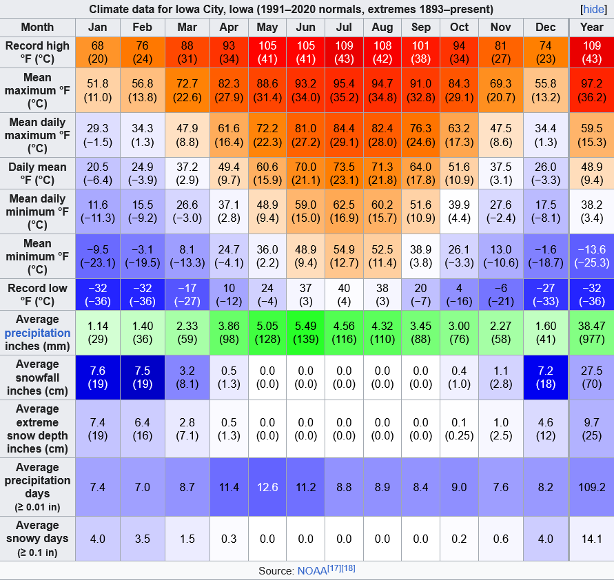
Climate of Iowa City
Iowa City is located in eastern Iowa, along the Iowa River, on Interstate 80, approximately 97 km west of the Quad Cities (Davenport and Bettendorf, Iowa, and Moline and Rock Island, Illinois).
According to the United States Census Bureau, the city has a total area of 65.47 km2, of which 64.78 km2 is land and 0.70 km2 is water. The elevation at the Iowa City Municipal Airport is 204 m above sea level.
Iowa City has a humid continental climate, hot-summer subtype (Dfa in the Köppen climate classification). Average monthly temperatures range from about −5.1 °C in January to 24.3 °C in July. Average monthly precipitation is lowest in winter and peaks significantly from May to August, with June being the average wettest month. Showers and thunderstorms are common from May to September, and can be severe, especially from May to July. In winter, snowfall is moderate, occasionally heavy in single storms. Snow cover is occasional in drier and/or warmer winter seasons, but (rarely) can be continuous in the coldest seasons, such as that of 1978–79. The Iowa City area was struck by a severe hailstorm on May 18, 1997, and by tornadoes on April 13, 2006. Overall, Iowa City's tornado risk is lower than that of areas to the south and southwest, such as Oklahoma, Kansas and Missouri.